Friday, February 11, 2011

2000 people show up to Shiawassee River Races

Way back in 1963 , approximately 2,000 people watched the
8th Annual, Durand Sportsman Association,  boat races on the Shiawassee River  
The 18 mile race started down in Byron,MI and ended at the Shiatown Dam in Durand, MI


The Shiawassee River can be brought back to a navigable level for all of Michigan to enjoy !
It is not outside the realm of possibility - Myself and a few others have paddled 40 miles in 1 day.


Canoe and Kayak races on the Shiawassee River can rival those of the Ausable and Grand River


The Shiawassee River in the vicinity of Byron,Michigan needs a concentrated effort
to remove deadfall trees using chainsaws this summer to make the river navigable.


https://picasaweb.google.com/lh/albumMap?uname=WilliH2O&aid=5463507338856007873#map 

-
-
-
-

Thursday, February 10, 2011

1873 Shiawassee Town map


Info taken from Page 6 in the Argus Press August 19, 1982
http://news.google.com/newspapers?id=_U8iAAAAIBAJ&sjid=Kq0FAAAAIBAJ&pg=1608,3985750&dq=shiawassee+town&hl=en

The location of the Grist Mill, Paper Mill and Saw Mill can be see on the map near the dam site
-

Sunday, February 06, 2011

Fiscal respect in Paddling sports versus fishing ?

Does paddlesports get the same fiscal respect as fishing in Michigan ?
What is the $ dollar value of Paddlesports to the Michigan economy versus the fishing industry ?

http://www.outdoorindustry.org/images/researchfiles/2009%20Paddlesports%20Report.FINAL.pdf

Canoes and Kayaks dominate boating throughout the USA
http://www.examiner.com/kayaking-in-detroit/canoes-and-kayaks-dominate-boating

Out of all the possible boat types available to the public at large
(16 years or older) over 20 % of them choose to use a kayak or canoe.

Paddlesports provides revenue to the economy via purchases in local communities for lodging, restaurants, supplies, gasoline, shopping, etc.

-
-

Paddlesports recreation and dam removal

Dam removal  often  puts fishing concerns above those of the paddlesports industry and recreation.

Based on extended analysis of data collected for the Outdoor Recreation Participation Report using
the responses of over 40,000 Americans ages six and older - paddlesports is rapidly growing in the USA

17.8 million Americans ages 6 and older participate in kayaking, canoeing, and rafting

Kayaking has enjoyed steady growth in spite of the economic slump growing 3% each year.

The survey is the largest of its type examining participation in sports and outdoor activities.

http://www.outdoorindustry.org/images/researchfiles/2009%20Paddlesports%20Report.FINAL.pdf?79

Paddlers bring extensive revenue to communities via purchases for lodging, gasoline, restaurants, etc., etc.

Obstacles to fish ARE OFTEN obstacles to Paddlesports also - and our voice is powerful in $$$$  !

Friends of the Shiawassee River Annual Meeting: February 24 2011

The Friends of the Shiawassee River  Annual Meeting

- Thursday, February 24 · [ 7:00pm - 10:00pm ]
-  First United Methodist Church
- 1500 North Water St
-  Owosso, Michigan

Owosso Assistant City Manager Adam Zettel will discuss how to best integrate the Shiawassee River, which was identified by City Council as a proirity in 2011 in city planning efforts. All members of the organization are encouraged to attend,... as well as local and regional planning representatives and members of the community.

A suggested $5 donation is recommended and light refreshments will be provided.
Zettel will introduce the topic of “Integrating the Shiawassee River into Planning Efforts.” 

The event will be an open dialogue for members and the community to discuss assets of the River and potential for protection and development. 

“The Shiawassee River is a special place for the community. It helped establish and foster the growth of Owosso and other unique places and we hope to see it featured as an important piece of community development efforts,” said Heidi Frei, Director of the Friends of the Shiawassee River. 


The Friends will also elect new officers and recognize volunteers and local businesses for their assistance with the organizations conservations efforts. RSVP is not required, but encouraged.

For more information, please contact Jen McMillon at jmcmillon@ShiawasseeRiver

The Friends of the Shiawassee River are an all volunteer organization committed to improving the environment, promoting responsible use of, and enhancing the appreciation of the Shiawassee River throughout its watershed. 


For more information visit Friends of the Shiawassee River at www.shiawasseeriver.org

-
-

Aging dam crisis in Michigan

Dam removal in Michigan needs to be streamlined and fast tracked by a think tank of professionals which most definitely include paddling aficionados, paddlesports retailers, and the ACA - American Canoe Association. Michigan has an enormous amount of creeks, streams, rivers, ponds, channels and lakes; all of which need attention.


Aging Dam Crisis in Michigan


Friday, February 04, 2011

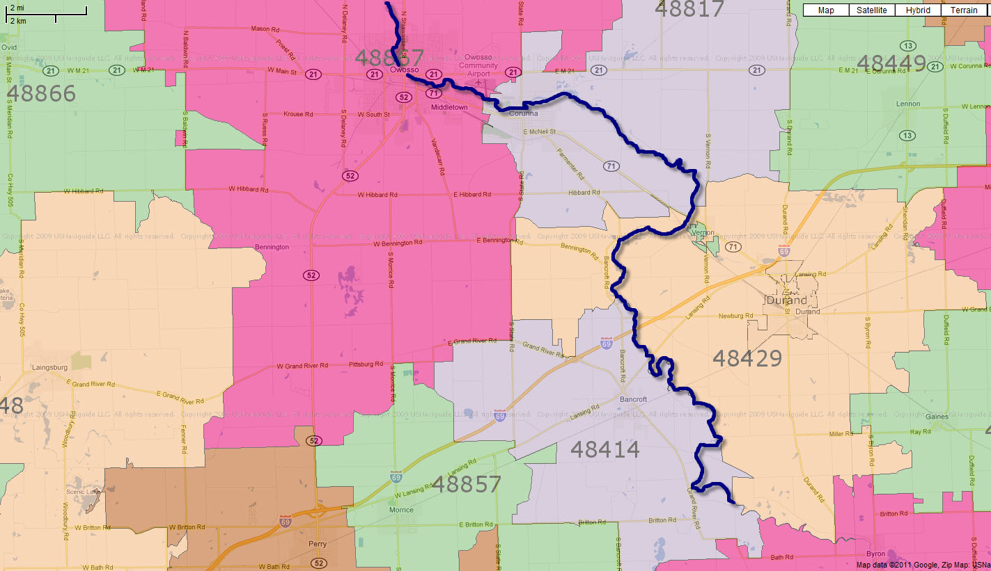
Shiatown Dam in Durand, Michigan 48429

Spoke to the USA postal office and the Shiatown Dam is definitely in Durand, MI zip code 48429
The nearest major crossroads intersection is the corner of Bancroft Road and Bennington Road in Durand, MI

http://www.geonames.org/7648758/shiatown-dam.html
Shiatown Dam


Shiatown Dam is in Durand, Michigan 48429  -- click on image for enlarged, detailed view

Verified via :
USA Post Office
211 North Oak Street, 
Durand, Michigan 48429
(989) 288-3876
-
-


Thursday, February 03, 2011

Aerial View Shiatown Dam

Lat=42.929668 Lon=-84.072257

Click on pictures for a larger, more detailed view


Sunday, January 30, 2011

SeeClickFix for Shiatown Dam removal

SeeClickFix for Shiatown Dam removal  -- http://www.seeclickfix.com/issues/77906


Antiquated dam providing NO flood control and is dangerous for kids to climb on.
Removal eliminates danger, creates more park acreage, and returns the river to its natural free flow.

Owner - Michigan Land Bank
Jeff Huntington
Senior Property Analyst
517-636-4898

Saturday, January 29, 2011

State took ownership of Shiatown Dam in 1999

In 1999 the private owner of the dam defaulted on taxes and the Shiatown Dam
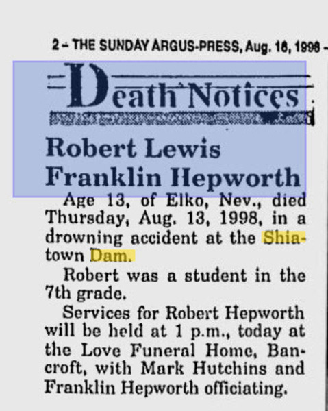
reverted to state ownership -- perhaps also because of the death in 1998
of a 7th grader at the site ?


---

Video of Shiatown Dam at Flood Stage

 It would appear this bit of video footage was shot in fall of 2008 - check out USGS data below video

Video of Shiatown Dam at flood stage

-
-

Friday, January 28, 2011

Shiatown Dam Resevoir shrinkage once dam is removed

On February, 13, 2001, the Shiawassee River near Shiatown Dam rose to 7 feet 8 inches. The National Weather Service issued a flash flood watch, and at 9
p.m. the river was 2.5 inches from the top of the dam.

Feb. 2001 reports in Owosso showed the Shiawassee River at Owosso exceeded flood stage of 7 feet at 2 pm on the 9th. The river crested at 8.2 feet at 10 pm on the 10th. After briefly falling below flood stage, the river saw a secondary flood crest of 7.3 feet at 1 am on the 14th.


Anything clogging the spillways will reduce the dam’s capability to handle a flood event and put the structure out of compliance with safety standards. The current logjam demands attention from the owner because it is out of compliance in 2011.

The area surrounding the dam is sparsely populated. Currently the reservoir pond behind the dam covers less than 50 acres, a massive reduction from the 1960's when it once covered 120 acres. Shrinkage of the reservoir pond once the Shiatown Dam is removed is insignificant to the community.

The Michigan Land Bank owns the dam. Shiawassee County Parks and Recreation Commission operates the 35 acres around the dam as Shiatown Park, East and West.
The dam is dangerous for children to climb upon or gain access to. Removal of the dam would enhance the surrounding by eliminating a manmade hazard.

Click on the illustration below for a larger view of the park :


Friday, January 21, 2011

Shiatown Reservoir Sedimentation testing

Sedimentation Testing - Historical Lab Data -
http://www.doxtop.com/browse/965f9d68/shiatown-resevoir-sediment-testing.aspx

The Shiawassee Town Reservoir is 42 Miles downstream from the Superfund site in Howell, Michigan.

Research regarding sedimentation at the dam site revealed this report from 2009 :
http://www.epa.gov/region5superfund/fiveyear/reviews_pdf/michigan/shiawassee_river_2009_334790.pdf


Contaminant Migration statement in the 2009 report
"""Based on the comparison of data from 1988 and 1999, the PCBs appeared to be dispersing downstream from the CFC facility, without accumulating in any particular location. Sampling in the Shiawassee town Reservoir and Shaw Lake downstream of the CFC facility, which would act as sediment traps for material moving downstream, primarily showed nondetectable levels of PCBs.""""

A study from May 2006 by Mark A. Coscarelli with the Partnership for the Saginaw Bay Watershed
--identified the dams at Chesaning, Owosso, Corunna, and Shiatown on the Shiawassee River as candidates for removal

http://www.fw.msu.edu/~rileysh2/enhancing_fish_passage.pdf

-Sharon Hanshue - Michigan DNR Legal - questioned the Future of the Shiatown Dam as well back in 2008
The Great Lakes Fishery Trust and Michigan Sea Grant had the Shiatown Dam listed for study in its strategic plan.
"The dam requires considerable repairs to stabilize it over the long term and the DNR
is only able to support emergency maintenance for the structure"

http://www.miseagrant.umich.edu/downloads/research/RFP/RFP-02-27-08.pdf

-
-

Monday, January 17, 2011

Wednesday, January 12, 2011

ShiawasseeWatershed Detailed Map

ShiawasseeWatershed_11x17.pdf (application/pdf Object)

This a great map showing where the dams exist
-
-

Monday, January 10, 2011

Shiatown Dam Inspection Report 2010

Shiatown Dam Inspection report 2010

Saginaw Bay Watershed blocked by dams

Fish Passage

The Saginaw Bay watershed is fragmented by nearly 300 dams or spillways . Improving fish passage at existing dams, either by ladders or by dam removal is the single surest means with which to increase natural reproduction. River spawning walleyes are already abundant in the bay, and are the only proven source of natural recruitment.  Establishment of fish passage and/or removal of unnecessary dams, while no small undertaking, can pay great dividends in terms of enhancing walleye recruitment. Enhancement of fish passage will also benefit lake sturgeon, white bass, and a variety of other warm water species. 


Figure 1. Saginaw Bay watershed. Dots indicate the location of a dam or spillway obstacle.


Dam removal is the preferred option for maximizing the benefits of natural reproduction. Dam removal eliminates the problem of safe and effective downstream transport of walleye fry which may otherwise be retained above dams or killed in hydroelectric turbines. Removal of dams also facilitates recovery of high gradient river reaches which are often necessary for successful natural reproduction.

Saginaw Bay's fishery is already valued at well over $18,000,000 in the 1990's 
and accounts for 58% of the total sport fishing effort on the Michigan waters of Lake Huron.

Excerpt taken from :
Strategy and Options for Completing the Recovery of Walleye in Saginaw Bay
David G. Fielder
Michigan Department of Natural Resources
Fisheries Division
Lake Huron Basin Team
August 2002


Saturday, January 08, 2011

Shiawassee River Heritage Water Trail Brochure

A look at the Shiawassee River Heritage Trail Brochure available soon to the general public

Shiawassee River Heritage Water Trail - Brochure Inside | Flickr - Photo Sharing!

-
-

How the Shiatown Dam got it's name

Back in 1836, Charles Bacon filed survey documents from the area (aka a plat file) to start a company involved with the buying and selling of land.

On July 12, 1837, Lemuel Brown, postmaster, opened the Post Office as Shiawassee. 1837 is also the time when Michigan became a state.

On May 26, 1857, the Post Office was renamed Shiawassee Town

The city was planned as a possible State Capital with 90 city blocks, two town squares and a park. 

Today it is a sparsely populated community with approximately 3,000 people for all of Shiawassee Township

Records indicate a dam was first built on the Shiatown site in 1840

In 1904 the original Shiatown Dam was replaced, and the Shiawassee Light and Power Company built
a structure for hydroelectric power generation and operated the facility until 1911.

In 1911 the Shiawassee Light and Power Company sold the hydroelectric dam to Consumers Power Company.

In 1955 Consumers transferred ownership to Shiawassee and Vernon Townships.

In 1964 Vernon Township transferred their share to Shiawassee Township.

During the 1960's, Shiawassee County operated the dam and impoundment as a recreational facility

In the early 1970's,  the formal ownership of the site was taken by Shiawassee County

In 1986 , Shiawassee County sold the dam to the Grand River Power Company.

Between 1986 - 1999, a  total of four different start-up power companies attempted ownership

In 1999 the private owner of the dam defaulted on taxes and the Shiatown Dam reverted to state ownership

The State of Michigan , in one form or another, call it what you will, HAS OWNED the Shiatown Dam since 1999

In 2011, The Michigan Land Bank Fast Track Authority had issued a report to the DNR regarding status
-
-

Wednesday, January 05, 2011

Rick Snyder split DNRE

For 2011 it is now two separate groups - the DNR and the DEQ  

EO-01-2011_342039_7.pdf (application/pdf Object)

-
-

Monday, January 03, 2011

Michigan's bizzare DAM ownership fiasco

Michigan has numerous DAMS in ownership limbo from judicial juggling of responsibility.
Let's cut the bullshit.
The government is US, the citizens of the Michigan. Waterways belong to everyone, downstream/upstream, all.
Attempting to burden some little itty bitty community of a 1,000 people with $$$$ millions in removal or repair costs is just a complete waste of everyones resources.

The State of Michigan should own all the dams, repair and maintain them along with demolition of  aging deteriorating dams that pose safety hazards.
Dams were used by our ancestors in an era long gone. It is time to evolve into the 21st century.


Corunna, Michigan is playing a game of who,what,where,when concerning ownership of a dam on the Shiawassee River.
Guess what - it belong to all of us in Michigan already.
Your tax dollars are paying the "experts" from the DNR and the Army Corps of Engineers to consult anyways.
Little local governments don't have super duper technical hydro engineers, physicists, structural engineers, etc.

Putting a dam in the hands of the Michigan Land Bank Authority is even more foolish.
It's not something anyone can sell, let along give away to a charity, or make any profit on.
They are bankers, CPA's and office personnel - it's not like they put on a drysuit and inspect the dams......

Water flows, it moves, it seeps, creeps, drips, and gurgles it's way along, never really staying in any one place for long.
It is a resource that belongs to all citizens of Michigan - and the government also belongs to us .
Citizens need to get actively involved with the resources they own .

Last time I checked, no one is getting their grain milled from any mill pond. It is 2011 - move forward !
http://t.co/KBVRFHP

-
-

Monday, December 27, 2010

UPDATE - Big blue construction crane on Shiawasee River

Update on the Big Blue Crane construction project near Eagle Road and Railroad

Response from Michigan DNRE rep, Melanie Foose:
The work that you are observing is being conducted by Enbridge and is part of the 6B pipeline that runs from Chicago, through Kalamazoo and up into Ontario.  Several portions of this line have required repair in Oakland County.  Prior to the work, I had walked this site of proposed work for Enbridge, as well as other sites in the county.  I had some concerns regarding the stream, the high quality wetland surrounding the stream – wetland that interestingly enough extends up the hill from the river with a likely groundwater seep, and also some concerns over certain rare species.  We did end up issuing a permit for the work – modified from their original proposal.   I expect that the work is close to finished or even completed by now, as they were hoping to have it done before Christmas.
-Melanie Foose

http://www.panoramio.com/photo/45239277

http://www.panoramio.com/photo/45239643

Line 6B is a 30-inch, 283,000 barrels per day (bpd) line transporting light synthetics, heavy and medium crude oil from Griffith, Ind., to Sarnia, Ontario. It is part of the Partnership's Lakehead System. The 1,900-mile Lakehead System is the U.S. portion of the world's longest petroleum pipeline and has operated for more than 60 years. The system is the primary transporter of crude oil from Western Canada to the United States, spanning from the international border near Neche, N.D., to the international border near Marysville, Mich., with an extension across the Niagara River into the Buffalo, N.Y., area. It consists of approximately 4,700 miles of pipe with diameters ranging from 12 to 48 inches; 60 pump station locations; and 66 crude oil storage tanks with a capacity of about 12.1 million barrels.
-


Thursday, December 23, 2010

Mid Shiawasee River Report

This report gives highly detailed info concerning the Shiawassee River

Midshiawasee-River-report_334332_7.pdf (application/pdf Object)

An Example:
Rainfall Frequency Atlas of the Midwest, Bulletin 71, Midwestern Climate Center, 1992.


-
-
Every 2 years, there is 50% chance, of getting a heavy thunderstorm dumping
2.42 inches of rain within a 24 hr period in the region.
-
If the weather man says we got 3 inches of rain in a 24 hr period, it's pretty significant news.
Back in August 2007, over 5 days, this area of Michigan received 5.12 inches of rain.-
-
Mid-Shiawassee River Watershed  - Hydrologic Study - 9/30/2010 -  page 30
The Shiawassee River watershed is both a snowmelt-driven and a storm-driven system. In a storm-driven system, rainfalls during the growing season generate flood flows. Snowmelt-driven systems are usually less flashy than storm-driven systems, because the snow pack supplies a steadier rate of flow. However, a rain-on-snow event, where rain and snowmelt simultaneously contribute to runoff, can produce dramatic flow increases. The runoff from the rain and snowmelt also likely occur with saturated or frozen soil conditions, when the ground can absorb or store less water, resulting in more overland flow to surface waters than would occur otherwise. Although the Mid-Shiawassee River watershed is likely more of a snowmelt-driven system, the increasing imperviousness of urbanizing tributary watersheds may shift those watersheds toward more storm-driven systems.

Saturday, December 18, 2010

Panoramio - Photo of Blue Manitowoc Crawler Crane

Panoramio - Photo of Blue Manitowoc Crawler Crane

Came across an Industrial Crane near the intersection of Eagle Road and the Railroad tracks in Holly, Michigan

http://picasaweb.google.com/WilliH2O/ConstructionCraneShiawasseeRiver#


Hopefully they pulled all the proper permits for construction.

-
-


National PipeLine Mapping Service shows pipelines and operators in Oakland County
http://www.npms.phmsa.dot.gov/default.htm

-

Thursday, December 16, 2010

Good news - Shiatown Dam cleanup to ocur Spring 2011

Report due to Byron Lane at DNRE from Jeff Hollington at MLBFTA this week-- before Christmas 2010 !

Jeff Huntington,
Property Analyst
Michigan Land Bank Fast Track Authority
517.636.4898 phone
huntingtonj@michigan.gov

Jeff apparently has contractor bids to clean up the mess in the spring of 2011.
MLBFTA apparently wants no part of owning a dam - demolition removal perhaps...........
The real decisions are made via the good knowledgeable people at the DNRE.

There will be plenty of eyes on the project in 2011 as the Shiawassee River evolves.
-
-

Shiatown Dam Google Earth Image April 2009


(please click on the picture with your mouse to see enlarged view)

Notice the date of the Google Earth Imagery for this satellite view :  April 1, 2009

My picture taken and posted on Panoramio in April 2010 confirms the logjam still exists.
-

'Small ice jam' on Shiawassee River may have caused flood warning, but no damage seen | MLive.com

'Small ice jam' on Shiawassee River may have caused flood warning, but no damage seen | MLive.com

Wednesday, December 15, 2010

Who owns the ShiaTown Dam on the Shiawassee River ?

Technically the Shiatown Dam belongs to MLBFTA - Jeff Huntington is the Property Analyst

MLBFTA - michigan land bank fast track authority ---- the group that gets tax foreclosed properties

Any real work on water dams gets done by the engineers, consultants and experts at the DNRE in Michigan.

http://www.panoramio.com/photo/44860767


Contact the MLBFTA


Jeff Huntington
Senior Property Analyst
517-636-4898
huntingtonj@michigan.gov


NWS Hydrologic Information Center

NWS Hydrologic Information Center

Flood warning issued for Shiawassee River near St. Charles, Chesaning | MLive.com

Flood warning issued for Shiawassee River near St. Charles, Chesaning | MLive.com

Monday, December 13, 2010

DNRE - legal stance

Since 1999, the Shiatown Dam has been owned by the Michigan Department of Natural Resources (DNR).  It acquired the Shiatown Dam as a tax-reverted parcel.

Other reports claim the dam is owned by the MLBFTA michigan land bank fast track authority.

The water in FRONT of the dam are public waters, open to anyone. Hence logjams could be removed.
Physically climbing upon the dam "might" be a liability issue, since it's a 19ft drop onto the concrete below.


While the DNR does oversee fisheries protection and recreation in Michigan,
its mandate does not include the operation or maintenance of dams. 

The agency is guided by the seven-member, governor-appointed Natural Resources
Commission and is funded by state general fund revenues, federal funds and a
variety of restricted funds.

Sharon Hanshue  is the Legal Services Coordinator from the DNRE in Lansing, Michigan Area
She can be reached at 517-335-4058

Operating out of the Office of Science and Policy, she coordinates litigation on behalf of DNRE
and provides central Exec level assistance for rules and policy development, directors orders,
interagency agreements and related work.

The dam's owner is expected to keep the structure in good repair - the dam safety act is Part 315 of the Natural Resources and Environmental Protection Act, PA 451 of 1992 and is administered by the DNRE - Water Resources Bureau.

Byron Lane is the program manager for dam safety.He can be reached at 517-241-9862
http://www.linkedin.com/in/byronlane


Byron is Chief of the Hydrologic Studies and Dam Safety Unit of the Michigan Department of Natural Resources and Environmental (DNRE) which regulates the safety of state regulated dams and provides flood discharge estimates, hydrologic modeling services and drought flow estimates to internal and external customers.

These are the KEY players to getting dams cleaned up along the Shiawassee River

-

Saturday, December 11, 2010

Responsibility for Massive Mess in Shiawassee County ?

Who decides along the Shiawassee River to clean this up - city, county, state ?


-
(click on the picture for a full screen view in high detail)

It is visible on Google Earth satellite views of the Shiawassee River


http://www.panoramio.com/photo/44860767
 (click on the link above to see latitude/longitude)


Who is responsible for keeping the Shiawassee River clean ?


Townships, Charter Townships and Cities of Shiawassee County

15 Townships, 1 Charter Township, 5 Cities

Cities of Shiawassee County

5 Cities, 6 Villages, 22 Unincorporated Places

Monday, December 06, 2010

December kayaking on the Shiawassee

Nothing quite like a December kayak paddle on the Shiawassee River.

http://bit.ly/ShiSnow

Doug Lanyk, Steve Hoffman and myself logged 17 miles on the river between Harmon Partridge Park in Owosso, Michigan and Ditch Road Park near Chesaning, Michigan

-
-

Friday, December 03, 2010

Argentine bridge on Lovejoy Road now open

The Lovejoy Road Bridge in Argentine over the South Branch of Shiawassee River
is now open for traffic after 8 year closure.

It is located between Sheridan and Duffield roads and covers
a 70-foot span over the river.

http://www.mlive.com/fenton/index.ssf/2010/12/lovejoy_road_bridge_in_argenti_1.html

-
-
-

Tuesday, November 30, 2010

REI Awards Grant for New Fenton Launch Site

REI Awards Grant for new Kayak and Canoe Launch Site in Fenton,Michigan at Bush Park

On behalf of the newly formed volunteer group promising to look after river issues in the Fenton to Argentine stretch -- Keepers of the Shiawassee -- Headwaters Trials applied for and received a grant in the amount of $3579. It is the plan of Keepers to encourage urban kayaking by developing a short learning paddle river segment around Bush Park in Fenton, Michigan.

http://www.cityoffenton.org/parks/bush.asp

The Fenton Rotary Club has an annual commitment to maintaining and improving that park. They will install an at-grade launch next to the Gazebo which can be accessed from North Leroy street. Then next spring Keepers will grade the banks and create a similar launch site one-eighth of a mile upstream.

Novice paddlers, especially families with children, will be able to practice their canoe or kayak skills from one launch to the other, all within the reach of Bush Park amenities--parking, restrooms, playscape, and picnic areas.

Southern Lakes Parks and Recreation will offer classes for children and adults using this stretch. Collectively, all participants hope to introduce new participants to the river and its possibilities for close to home recreation.

REI is a national outdoor retail co-op with three stores in southeast Michigan--Troy, Northville and Ann Arbor.


http://www.headwaterstrailsinc.org/about_us.htm
-
-

Wednesday, November 24, 2010

Search the blog


If you can't find what you want, please use the customized search unique to the blog

-
http://blogsearch.google.com/
-
-

Sunday, November 21, 2010

Shiawassee River Launch Sites : Saginaw County, Michigan

Shiawassee River Launch Sites

Saginaw County, Michigan
Miller Road - Shiawassee Flats
From M-46, west of Shields at Miller Road signal, head south to dead end (over 4 miles).
GPS: N 43 21.458, W 84 04.331
St. Charles DNR Ramp - Bad River
Heading south into St. Charles. Turn left at the DNR sign at the bridge.
The ramp is opposite the DNR building, on the river.
GPS: N 43 17.950, W 84 08.471
St. Charles - Bad River, down river site
Heading south into St. Charles, go past the intersection where HWY 52 veers to the west.
Continue south until the road angles west and turns into Chesaning Street (about 4 blocks).
Follow Chesaning St. a block and a half to Hulien Road.
Turn left (east), and proceed to the dead end. Turn left (north), and continue to the river.
Parking is fair. Do not attempt to use this site turning flood times.
GPS: N 43 18.188, W 84.06.587
Oakley (Old Dam Site)
Go through St. Charles on HWY 52, to about 6 blocks east of Oakley.
GPS: 43 08.373, W 84 09.590
Henderson Park
Go through St. Charles on HWY 52, past Oakley to Henderson Road (approximately 15 miles from downtown St. Charles).
Turn right (west) onto Henderson Road, and head into the park.
The park is located at the junction of the river/bridge and Henderson Road.
GPS: 43 05.206, W 84 10.997
 
Originally posted by the nice folks at the East Coast Paddlers group
East Coast Paddlers: Shiawassee River Launch Sites:

-

Saturday, November 20, 2010

Stream Stabilization & Restoration Guidance Documents

Stream Stabilization & Restoration Guidance Documents

Prepared by: Paul Bijhouwer, P.E., Hydraulic Engineer, CELRB-TD-HD Last Updated: 11/28/2005

Disclaimer: This listing is provided for educational purposes only and does not constitute USACE endorsement of the practices described in the references for any specific purposes. The practices of stream stabilization and restoration are highly complex and should only be undertaken under the guidance of experienced licensed professionals. As always, early coordination with agencies having permitting jurisdiction is highly advisable.

SOME INFO may prove more useful than others - poke around and see what fits your needs

HQUSACE Publications
Available at http://www.usace.army.mil/inet/usace-docs
ER 1110-2-1405 Hydraulic Design for Local Flood Protection Projects, 30-Sep-1982
EM 1110-2-1204 Environmental Engineering for Coastal Shore Protection, 10-Jul-1989
EM 1110-2-1205 Environmental Engineering for Local Flood Control Channels, 15-Nov-1989
EM 1110-2-1418 Channel Stability Assessment for Flood Control Projects, 31-Oct-1994
EM 1110-2-1601 Hydraulic Design of Flood Control Channels, 30-Jun-1994
EM 1110-2-1612 Ice Engineering, 30-Oct-2002
EM 1110-2-4000 Sedimentation of Rivers and Reservoirs, 31-Oct-1995
Engineer Research and Development Center Manuals / Reports / Technical Notes
The WES Stream Investigation and Streambank Stabilization Handbook, Oct-1997
ERDC/EL SR-W-00-1 Stream Management, Mar-2000
ERDC-CHL TR-00-15 Effective Discharge Calculation - A Practical Guide, Aug-2000
ERDC/CHL TR-01-28 Hydraulic Design of Stream Restoration Projects, Sep-2001
All downloadable through ERDC Digital Library searches at
http://134.164.46.19/uhtbin/cgisirsi/x/0/0/49/1?new_gateway_db=HYPERION
ERDC/CHL CHETN-VIII-4 Effective Discharge Calculation, Dec-2000
ERDC/CHL CHETN-VIII-5 Channel Forming Discharge, Dec-2000
Available at http://chl.erdc.usace.army.mil/CHL.aspx?p=s&a=ARTICLES;370
ERDC TN-EMRRP-SR-29 Stability Thresholds for Stream Restoration Materials, May-2001
Available at http://el.erdc.usace.army.mil/emrrp/tnotes.html (with numerous other Stream Restoration tech notes)

Institute for Water Resources
Illustrations of Environmental Engineering Features for Planning, Dec-1998
http://www.iwr.usace.army.mil/iwr/pdf/98r08.pdf 
Other (Non-USACE) – General 
Stream Corridor Restoration: Principles, processes, and practices, 1998
http://www.nrcs.usda.gov/technical/stream_restoration/ 
Comprehensive reference prepared by the Federal Interagency Stream Restoration Working Group
John McCullah’s Environmentally Sensitive Streambank Stabilization
http://www.e-senss.com 
 - Commercial version for purchase
http://trb.org/news/blurb_detail.asp?id=5617
- Freely downloadable public domain version
Contains design guidance, typical details, etc.
David Rosgen guidance / technical papers downloadable from Wildland Hydrology website
http://wildlandhydrology.com/html/references_.html
Guidance on design of j-hooks, cross-vane weirs, etc.

Stream Stabilization & Restoration Guidance Documents
Prepared by: Paul Bijhouwer, P.E., Hydraulic Engineer, CELRB-TD-HD
Last Updated: 11/28/2005 2:11 PM USDA Forest Service – Stream Systems Technology Center
http://www.stream.fs.fed.us 
USDA NRCS National Water Management Center – Regional Hydraulic Geometry Curves
http://wmc.ar.nrcs.usda.gov/technical/HHSWR/Geomorphic/index.html 
North Carolina Stream Restoration Institute
http://www5.bae.ncsu.edu/programs/extension/wqg/sri/presentations.html 
Links to Stream Restoration Design Principles course presentations.
Lots of other educational materials on this site.
Homepage of Douglas Shields of the USDA ARS
Review the online list of his publications.
Many useful publications are available for download at the second link.
http://www.ars.usda.gov/pandp/people/people.htm?personid=5120
http://www.ars.usda.gov/Research/docs.htm?docid=7269 
Doyle River Ecosystems Group
Link to the homepage for Martin Doyle, a Geomorphologist involved in river restoration work.
http://www.unc.edu/~mwdoyle 
Link to downloadable version of the excellent paper Design for Stream Restoration, Journal of Hydraulic Engineering 129(3):575-584, 2003, coauthored by Shields, Copeland, Klingeman, Doyle, and Simon. This paper defines a standard of care for hydraulic engineering of river restoration projects, and includes an extensive bibliography of useful references many of which can be Googled from the web.
http://www.unc.edu/~mwdoyle/pdfs/JHERestorationDesign.pdf 
Robert Newbury – Author of publication on design of rocked riffles - Stream Analysis and Fish Habitat Design – A Field Manual, 1993. This publication is available on-line at the ftp site given below. An updated version of the manual was also available for purchase, but is no longer found at the bookstore website. Try contacting Newbury through the website below for more info. Newbury also offers Stream Design courses.
ftp://ftp.lgl.com/pub/ Filename: Stream Analysis.pdf File size: 141 MB
http://www.newbury-hydraulics.com 
USGS National Flood Frequency computer program
http://water.usgs.gov/software/nff.html 
Free software automating computations using the USGS regression procedures for each state (see below)
Other (Non-USACE) – Ohio Specific 
USGS Open File Report 93-135 Estimation of peak-frequency relations, flood hydrographs, and volume-duration-frequency relations of ungaged small urban streams in Ohio, Sherwood, 1993
http://pubs.er.usgs.gov/pubs/ofr/ofr93135 
USGS Water Resources Investigation Report 03-4164 Techniques for Estimating Flood-Peak Discharges of Rural, Unregulated Streams in Ohio, Koltun, 2003
http://oh.water.usgs.gov/reports/wrir/wrir03-4164.pdf 
USGS Water-Resources Investigations Report 02-4068 Techniques for Estimating Selected Streamflow Characteristics of Rural, Unregulated Streams in Ohio
http://oh.water.usgs.gov/reports/Abstracts/wrir02-4068.html 
Ohio Department of Natural Resources / Ohio State University STREAM website
http://www.dnr.state.oh.us/soilandwater/streammorphology.htm
Natural Channel Design aids in Excel format

Prepared by: Paul Bijhouwer, P.E., Hydraulic Engineer, CELRB-TD-HD
Last Updated: 11/28/2005 2:11 PM
 
Other (Non-USACE) – New York Specific 
USGS Project 2457-A29-1 – Regionalization of Channel Geomorphology Characteristics for Streams of New York State, Excluding Long Island. This page describes the USGS effort currently underway to develop regional hydraulic geometry curves for the various hydrologic regions of NY.
Includes links to the completed publications.
http://ny.cf.er.usgs.gov/nyprojectsearch/projects/2457-A29-1.html 
USGS Water-Resources Investigations Report 90-4197
– Regionalization of Flood Discharges of Rural, Unregulated Streams in New York, Excluding Long Island
http://ny.water.usgs.gov/pubs/wri/wri904197

-
-

Saturday, November 06, 2010

Americans Vote Yes For Conservation - Science

-
Despite tough economy, people want to fund land and water protection

Americans Vote Yes For Conservation - Science

-
-

Thursday, November 04, 2010

Corunna discovers it doesn’t own troubled dam

City of Corrunna does not own the dam on the Shiawassee River

See Article in the Argus News

The Argus-Press: News - Corunna discovers it likely doesn’t own troubled dam

-
-
-

Wednesday, October 20, 2010

Corunna officials frustrated by state

Corruna council members ultimately approved filing a permit application to draw down the impoundment and abandon the dam.

The Argus-Press: News - Corunna officials frustrated by state

-
-

Thursday, October 14, 2010

DDA plan outlines projects for next 15 years

Shiawassee Riverwalk, a walkway on both sides of the river from Rackham Park toward Bush Park, $500,000.

Canoe Launches, two, accessing the Shiawassee River and Fenton Mill Pond, $160,000.


Tri-County Times > Archives > News > Local > DDA plan outlines projects for next 15 years

-
-

Saturday, October 09, 2010

Examiner publishing and I part ways

I gave the Examiner a shot for about a year , writing a variety of articles relating to kayaking, paddling, etc. - it has come to an end. No new published articles.

 The articles still appear at -----  http://www.examiner.com/kayaking-in-detroit/willi-gutmann

The reality of it all is that Examiner just doesn't pay for the time most writers will put into their stories.  By the time you get a story idea in your head, to the time you research some facts, find some pictures and videos, and then edit it all and publish - you're already on the dark side of the cold moon to recoup any costs.  Forget about getting into the Google News feeds.  Google and Examiner.Com don't play nice with each other any more. Examiner.Com has a rule about waiting until after an event happens for it to be considered news.  Absolutely no promotion of an event as a news feed before the event takes place is poor business.  Writing about an event as commentary, advice, opinion, etc. ; sure that was okay; but forget about getting into a news feed for large pageviews. Forget about Press passes because Examiner is not considered the press.  Each writer is an Independent Contractor, taking any liability responsibility off of the Examiner.

Examiner .com used to pay around a penny a pageview back in late 2009. After restructuring their platform and adding a tremendous amount of advertising to every millimeter of the webpage, payouts dropped to 7/10 of a cent per pageview.  In order to make $25.00 a month, I needed to generate enough interest in my work to get 3,500 pageviews, or roughly 120 page views per day , each and every day. Pretty damn tough with this paddling topic in the greater metropolitan Detroit area of Michigan. Writing daily for fresh new stories while staying laser focused on your topic and specific city venue  is damn tough.  Over a 12 month period (365 days)  I published around 200 articles and made a total of about $250.  The pay per pageview varies and fluctuates - please don't think it's locked at a specific number. Based on a black box of variables - time spent on the webpage, number of subscribers, number of clicks, etc., etc. it averages out to something like 7/10 of a cent a pageview. Some days are a lot less, some days are a teensy tiny bit more. No consistency at all on pay.

Examiner.Com does a great job at selling a dream but they don't deliver on it. Please be wary of thinking you'll be able to pay any of your bills by writing for them. You won't. People have extremely short attention spans on the internet, and unless you stuff every articles with pictures of celebrities, fashion, gossip, drama and hype, the pageviews just aren't there within the Examiner.Com. Getting on the front page and staying there for more than 15 minutes, forget about it. You'll get 15 seconds max,  and then be banished under some drop down menu into obscurity .  Even the super hardcore news websites are struggling to stay afloat.

Examiner .com does absolutely zero, nada, nothing, to promote any writer on the internet. ALL they do is provide a platform upon which someone can write about a topic. That's it. No more. Each and every pageview is a hard earned effort, scraped out out of every corner of the internet, bordering upon spamming all your known contacts, their friends, their contacts and for what - around $25.00 a month. Some months were a bit more with monetary incentives to write local articles and write daily. ROI is laughable.

I started writing on Examiner.com because I had a ton of info built up over 10 years + of scanning the web for paddling info on a massive variety of topics, issues, concerns, etc.  I felt I had something to offer from a unique perspective and definitely did not want to write Kayaking 101 articles every day.

I learned an awful lot in the beginning,  by paddling often with those more experienced than myself. Paddling is a learned skill, it is not inherent to our DNA at birth. No one "just knows how to paddle".  Acquiring good technique, situational judgment  , accurately determining if you are in over your head,  truly knowing the scope of your abilities, takes time in the cockpit with a paddle in your hand. Finding a paddling group that fosters an environment for learning plays a big role in evolving forward as a paddler.

Learning never stops ...we evolve as we move through life.
-
Examiner has fallen, and that's a fact proven by worldwide internet pageviews
-

-
-

Tuesday, September 21, 2010

Canoeing in Color: October 2, 2010

Canoeing in Color -- October 2, 2010


Come celebrate the Shiawassee River this fall on Saturday, October 2nd. 
Bring your canoe or kayak to WaterWorks Park in Holly on South Broad Street
We'll set off around 1:00pm or a little later if that suits your schedule. 
Heavner Canoes will again be on site offering rentals and shuttles 

North Oakland Headwaters Land Conservancy will co-sponsor this event, 
and give you a guide to preservation sites along the way. 

The three-four hour paddle could be heavenly, or the weather could be chilly, 
so plan accordingly. 

For more information, call 248-634-3513 (Sue Julian).


2008 Shiawassee Fall Color Tour Paddle

Monday, September 20, 2010

Another successful push forward - river cleanup

As told by Chuck Julian - Headwaters Trails Volunteer

The river cleanup went well on Sunday, Sept. 29, 2010.  We had 12 people put in at Hogan Road and take out at McCaslin Lake Road.  We cut one big tree and a couple of small ones, trimmed some face slappers and pulled a lot of trash out of the river (We lost two orange log cutting wedges at the newly cut big tree, let me know if you find them.  The water was a little to stirred up for us to see them once they hit bottom).  We started at 9 and finished at 2:30.  Afterward, we were served dinner at Ricky Ostrowski's house, played a game he called Polish horse shoes and enjoyed ourselves with each other's company.  We were able to transport the trash to the Argentine dumpster with the exception of the tires.  At this point, we are not sure what to do with them.  Thank you to everyone who came and thank you to Doug and Kristy Fairbanks for loaning us four canoes, their van and trailer.  We would not have been able to transport the all the trash without them.  Debbie McCarty transported the trash to Argentine, only then to have her water pump fail in her truck.  The recent rain has brought the river up a foot or more, so if it goes down again, there may be logs that need to be cut.

At the current river level, the Shiawassee River is clear from Water Works Park in Holly, to Bird Road in Argentine.  I am told that the stretch downstream from Bird needs a lot of work but that will have to wait till next summer.  Now is the time to enjoy the river.  The fall colors are just starting to come out.  Migrating ducks, Sand Hill Cranes and Blue Heron abound on the river.  It is a perfect place to relax and enjoy the natural beauty.

-
-
-
-

Tuesday, September 07, 2010

Shiawassee River walk on Labor Day weekend

More than 200 people attended the seventh annual event, which started on the Owosso Heritage Footbridge,
went along the scenic Shiawassee River, and ended in Corunna, Michigan


Hundreds in Mid-Michigan celebrated Labor Day by lacing up and hitting the roads | abc12.com
-
-

Saturday, September 04, 2010

Fix wet electronic kayaking gear with Silica Gel

We all have family and friends that own and use a variety of cellphones, mp3, gps, camera, watches, remote key fobs, etc. Inevitable some of those items get wet, dropped in the pool, the toilet, a puddle or perhaps dockside as someone launches a kayak.

Dry them out with a bit of silica gel and a zip lock bag

http://www.examiner.com/kayaking-in-detroit/fix-wet-electronic-kayaking-gear


Wednesday, September 01, 2010

Pics from Headwaters Trails Shiawassee River CleanUp 8/29/10

Pictures taken of many volunteers who gave their personal time to make the river a gem

Facebook | Headwaters Trails Shiawassee River Clean-up 8/29/10

-
-