Showing posts with label dam. Show all posts

Monday, May 02, 2011

Michigan laws regarding dam safety

The DNR - Department of Natural Resources is responsible for the safety of dams.

The department has the power to regulate the construction, reconstruction, repair,
alteration, removal, abandonment, and operation of dams.

The department may in an emergency take any necessary actions, including repair,
drawdown, breaching or cessation of operation to protect public safety,
natural resources and the public trust.

Michigan laws regarding dam safety


-
USGS topography map of the Shiatown Dam and surrounding land
( click on the picture with mouse for a larger view)

-


The Shiatown Dam is 19 feet high - the water drops 19ft from reservoir to spillway
-

Thursday, February 10, 2011

1873 Shiawassee Town map


Info taken from Page 6 in the Argus Press August 19, 1982
http://news.google.com/newspapers?id=_U8iAAAAIBAJ&sjid=Kq0FAAAAIBAJ&pg=1608,3985750&dq=shiawassee+town&hl=en

The location of the Grist Mill, Paper Mill and Saw Mill can be see on the map near the dam site
-

Sunday, February 06, 2011

Aging dam crisis in Michigan

Dam removal in Michigan needs to be streamlined and fast tracked by a think tank of professionals which most definitely include paddling aficionados, paddlesports retailers, and the ACA - American Canoe Association. Michigan has an enormous amount of creeks, streams, rivers, ponds, channels and lakes; all of which need attention.


Aging Dam Crisis in Michigan


Friday, February 04, 2011

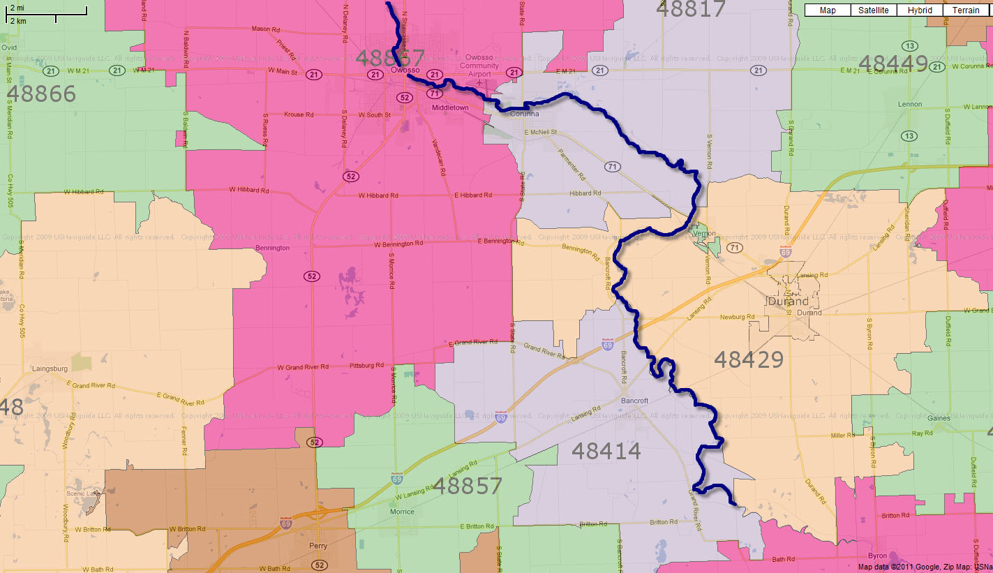
Shiatown Dam in Durand, Michigan 48429

Spoke to the USA postal office and the Shiatown Dam is definitely in Durand, MI zip code 48429
The nearest major crossroads intersection is the corner of Bancroft Road and Bennington Road in Durand, MI

http://www.geonames.org/7648758/shiatown-dam.html
Shiatown Dam


Shiatown Dam is in Durand, Michigan 48429  -- click on image for enlarged, detailed view

Verified via :
USA Post Office
211 North Oak Street, 
Durand, Michigan 48429
(989) 288-3876
-
-


Thursday, February 03, 2011

Aerial View Shiatown Dam

Lat=42.929668 Lon=-84.072257

Click on pictures for a larger, more detailed view


Friday, January 28, 2011

Shiatown Dam Resevoir shrinkage once dam is removed

On February, 13, 2001, the Shiawassee River near Shiatown Dam rose to 7 feet 8 inches. The National Weather Service issued a flash flood watch, and at 9
p.m. the river was 2.5 inches from the top of the dam.

Feb. 2001 reports in Owosso showed the Shiawassee River at Owosso exceeded flood stage of 7 feet at 2 pm on the 9th. The river crested at 8.2 feet at 10 pm on the 10th. After briefly falling below flood stage, the river saw a secondary flood crest of 7.3 feet at 1 am on the 14th.


Anything clogging the spillways will reduce the dam’s capability to handle a flood event and put the structure out of compliance with safety standards. The current logjam demands attention from the owner because it is out of compliance in 2011.

The area surrounding the dam is sparsely populated. Currently the reservoir pond behind the dam covers less than 50 acres, a massive reduction from the 1960's when it once covered 120 acres. Shrinkage of the reservoir pond once the Shiatown Dam is removed is insignificant to the community.

The Michigan Land Bank owns the dam. Shiawassee County Parks and Recreation Commission operates the 35 acres around the dam as Shiatown Park, East and West.
The dam is dangerous for children to climb upon or gain access to. Removal of the dam would enhance the surrounding by eliminating a manmade hazard.

Click on the illustration below for a larger view of the park :


Friday, January 21, 2011

Shiatown Reservoir Sedimentation testing

Sedimentation Testing - Historical Lab Data -
http://www.doxtop.com/browse/965f9d68/shiatown-resevoir-sediment-testing.aspx

The Shiawassee Town Reservoir is 42 Miles downstream from the Superfund site in Howell, Michigan.

Research regarding sedimentation at the dam site revealed this report from 2009 :
http://www.epa.gov/region5superfund/fiveyear/reviews_pdf/michigan/shiawassee_river_2009_334790.pdf


Contaminant Migration statement in the 2009 report
"""Based on the comparison of data from 1988 and 1999, the PCBs appeared to be dispersing downstream from the CFC facility, without accumulating in any particular location. Sampling in the Shiawassee town Reservoir and Shaw Lake downstream of the CFC facility, which would act as sediment traps for material moving downstream, primarily showed nondetectable levels of PCBs.""""

A study from May 2006 by Mark A. Coscarelli with the Partnership for the Saginaw Bay Watershed
--identified the dams at Chesaning, Owosso, Corunna, and Shiatown on the Shiawassee River as candidates for removal

http://www.fw.msu.edu/~rileysh2/enhancing_fish_passage.pdf

-Sharon Hanshue - Michigan DNR Legal - questioned the Future of the Shiatown Dam as well back in 2008
The Great Lakes Fishery Trust and Michigan Sea Grant had the Shiatown Dam listed for study in its strategic plan.
"The dam requires considerable repairs to stabilize it over the long term and the DNR
is only able to support emergency maintenance for the structure"

http://www.miseagrant.umich.edu/downloads/research/RFP/RFP-02-27-08.pdf

-
-

Monday, January 17, 2011

Thursday, December 16, 2010

Shiatown Dam Google Earth Image April 2009


(please click on the picture with your mouse to see enlarged view)

Notice the date of the Google Earth Imagery for this satellite view :  April 1, 2009

My picture taken and posted on Panoramio in April 2010 confirms the logjam still exists.
-

Thursday, November 04, 2010

Corunna discovers it doesn’t own troubled dam

City of Corrunna does not own the dam on the Shiawassee River

See Article in the Argus News

The Argus-Press: News - Corunna discovers it likely doesn’t own troubled dam

-
-
-

Wednesday, October 20, 2010

Corunna officials frustrated by state

Corruna council members ultimately approved filing a permit application to draw down the impoundment and abandon the dam.

The Argus-Press: News - Corunna officials frustrated by state

-
-

Tuesday, April 13, 2010

Getting stuff cleaned up is like pulling a live tigers teeth without anethesia

From: Basch, John [mailto:baschj@oakgov.com]
Sent: Tuesday, April 13, 2010 3:00 PM
Subject: Dam debris on Shiawassee River

Thank you for writing to the Oakland County Water Resources Commissioner’s Office about debris that is impeding the flow of water on the Shiawassee River. Unfortunately, this office lacks the authority to perform any cleanup in the area described in your e-mail. When public funds are involved, it is unlawful to expend those funds in areas where we lack jurisdiction. In this case, the jurisdiction of this office is limited to drainage systems established and constructed under the Michigan Drain Code. The land surrounding the dam is owned by the State of Michigan. You may want to solicit help from the state in addressing this issue. It may be helpful to you to know that the dam and box culvert mentioned in your e-mail are located within the “Davisburg State Game Area.” The body of water controlled by this structure also is known as the “Davisburg Trout Pond.” It is shown on most state maps as the “Davisburg Pond.” The state game area is in section 16 of Springfield Township. This information may help you with your investigation and attempts to have the debris cleared.

Best regards,

John A. Basch
Deputy and Legal Counsel
Oakland County Water Resources Commissioner's Office
248-858-4934 office
248-858-5090 fax
248-431-0179 mobile
baschj@oakgov.com


-