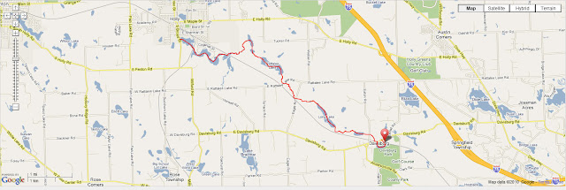
Pictures and GPS data from the Earth Day Adventure - 40 kayak miles in a day - Argentine to Corunna
http://bit.ly/ ArgentineToCorunna Geo-tagged, dated, and mapped
http://outdoors.webshots.com/album/577443260canNMX
( Nice clean high resolution pics from the trip )
Google Earth and Panoramio
http://www.panoramio.com/user/4402540
-
-
Kayaking Shiawassee River: Argentine,MI to Corunna,MI
I trust everyone had a wonderful Earth Day.
Steve H. Willi G. and I sure had a full one. Our Shi-trio Started 6:00
AM to spot a vehicle in Corunna MI. We then started at our last finish
point at McCaslin Lk. Rd. in Argentine. With an extra special amount of
gear to handle a variety of possible conditions we launched at 8:45.
The weather was clear sunny and brisk. It was almost 30 deg. when we
hit the water. The great news was tempered by the fact it wasn't
perfect news. There were 20 trees down blocking our path on the first
segment going to Byron. This was so much better than the hundreds of
trees I observed 2 years ago. Having lots of fun scooting under trees
or hopping them we made slow but steady progress. It took until noon to
finish the first 8 miles. If we can find just a few volunteers this
will be opened up to the less adventurous paddler.
After a quick lunch in Byron learning history from the residents and
spreading the word of the State Heritage River Trail we were off. The
portage needs some work but isn't worth more than minor complaints. We
found the confluence of the main branch and the South branch of the
Shiawassee and traveled up stream on the South branch just to say we
did. The last tree we had to hop was about 10 feet after the river
joined. At this point the Shiawassee changes from an intimate little
meandering stream to a full fledged river. Although blockages do occur,
mostly the trees that fall into the river don't reach the far bank
leaving a good passage. We sped past the launch point at Byron H.S. and
Headed North towards Walnut Hills Campground the next access point. At
this point we were making great time, (Willi will post his data
sometime.) so we sped past and headed for Geeck Rd. Park. This proved
to be a bit longer stretch than our energy reserves could easily
handle. Catching lunch #2 respectfully on the shore of some private
wooded lot a mile further we found the park. Onward we cranked. The
entire segment from Byron to pas I69 has moderate to fast current.
After Geeck Rd. Park more and more gravel and stone geology started
giving us minor white water or swifts. Just enough to make you pay
attention but not enough to be dangerous. This was quite fun. Not to
far past Newberg Rd the Shiawassee Town (Shiatown) pond starts ending in
a very nice park at Shitown. Time for another snack and a little bit of
playing at the base of the dam. This could be fun at moderate to high
flow rates but we did not have the proper safety gear. I'd want
helmets, throw bags, heavy skirts, and competent partners to handle this
stuff at high water. The next segment to Vernon and on to Corunna is a
long quick paddle. We were starting to run low on energy and muscles at
this point. Shiatown was about 32 miles into our trip. More moderate to
quick current was welcomed and stayed with us up to the gravel mine a
mile and a half from Corunna. They have a concrete road across the
river! Willi and I were so tired by this point we struggled to crawl
out of our boats to cross the road. It was after that we noticed you
can pass on the left. We new there was little energy, brains, or
motivation left. The sun was setting and we were getting cold. Steve
had gone ahead to get his van at the park in Corunna past the dam.
Speaking of the dam As we limped into town with the last of the day
lingering in the sky we noticed that there in nothing to stop you from
paddling over the dam except the roaring of the water. Don't do this at
night folks. We pulled out and waited for Steve to bring the van around
to load up Finish time 9:00 PM. Condition exhausted hypothermia, and
hungry. Distance 40 Miles.
The wildlife was not prolific but varied. Dear, beaver, muskrat, mink,
porcupine, a books worth of birds, amphibians.and fish kept us in
wonder. The fact that we saw maybe a dozen people all day was great
too. I would advise trying out all the sections of the Shiwassee as they
are varied and interesting. I will not advise doing 40 miles in a day
before the river is cleared.
One last note. We walked into the Wrought Iron Grill in Owosso at
10:30 We had been looking forward to a good meal at a known excellent
restaurant . The bartender advised us that the grill was closed (go
figure) and we should talk to the owner in the blue shirt. This
wonderful man interrupted his conversation with friends to listen to a
plea from 800 lbs plus of hungry men and helped us out. He figured out
a meal that he could make without trashing the whole kitchen, and came
out with enough food to stop even our ravenous apatites We had the
rapt attention of all the patrons as we explained how great a time we
had on the river. It was time to go home. I got into bed about 1:30 AM
this morning.
What a wonderful Earth Day!
Sincerely
Douglas Lanyk
Saturday, April 24, 2010
Wednesday, April 21, 2010
Huron River trip
HURON RIVER KAYAK TRIP : Tuesday April 20, 2010
Extremely low water levels displayed all the stone weirs, many sweepers, fallen trees, and debris.
Navigability is a bit tricky in spots and could use a bit of cleaning up for ordinary canoe traffic in the summer.
http://picasaweb.google.com/WilliH2O/IslandRecToHuronMeadows02#
http://picasaweb.google.com/lh/albumMap?uname=WilliH2O&aid=5462435978828525777#map
http://www.panoramio.com/user/4402540
-
-
Saturday, April 17, 2010
Friday, April 16, 2010
Paddling on Concrete
You just might me see around paddling on concrete ........yes I said concrete.
Paddling on Concrete
-
-
Paddling on Concrete
-
-
Thursday, April 15, 2010
Maps - GeoNames - interactive
If you aren't sure where WaterWorks Park in Holly, Michigan , or Strom Park in Fenton, Michigan are located
along the Shiawassee River perhaps these links will be of assistance.
GeoNames
http://www.geonames.org/maps/bkm11191
along the Shiawassee River perhaps these links will be of assistance.
GeoNames
http://www.geonames.org/maps/bkm11191
Wednesday, April 14, 2010
GPS geotagging merged with maps
Here is an attempt using Picassa, my Garmin GPS, and Google maps
http://bit.ly/ PicsMergedGoogle Maps
http://picasaweb. google.com/ lh/albumMap? uname=WilliH2O&aid=545977538087734 7649#map
During the 22 mile kayak paddle on the Shiawassee between Holly and Argentine last Saturday,
I shot lots of pics of culverts, bridges, walkways, etc.
http://bit.ly/ PicsMergedGoogle Maps
http://picasaweb. google.com/ lh/albumMap? uname=WilliH2O&aid=545977538087734 7649#map
During the 22 mile kayak paddle on the Shiawassee between Holly and Argentine last Saturday,
I shot lots of pics of culverts, bridges, walkways, etc.
Tuesday, April 13, 2010
Getting stuff cleaned up is like pulling a live tigers teeth without anethesia
From: Basch, John [mailto:baschj@oakgov.com]
Sent: Tuesday, April 13, 2010 3:00 PM
Subject: Dam debris on Shiawassee River
Thank you for writing to the Oakland County Water Resources Commissioner’s Office about debris that is impeding the flow of water on the Shiawassee River. Unfortunately, this office lacks the authority to perform any cleanup in the area described in your e-mail. When public funds are involved, it is unlawful to expend those funds in areas where we lack jurisdiction. In this case, the jurisdiction of this office is limited to drainage systems established and constructed under the Michigan Drain Code. The land surrounding the dam is owned by the State of Michigan. You may want to solicit help from the state in addressing this issue. It may be helpful to you to know that the dam and box culvert mentioned in your e-mail are located within the “Davisburg State Game Area.” The body of water controlled by this structure also is known as the “Davisburg Trout Pond.” It is shown on most state maps as the “Davisburg Pond.” The state game area is in section 16 of Springfield Township. This information may help you with your investigation and attempts to have the debris cleared.
Best regards,
John A. Basch
Deputy and Legal Counsel
Oakland County Water Resources Commissioner's Office
248-858-4934 office
248-858-5090 fax
248-431-0179 mobile
baschj@oakgov.com
 -
-
Sent: Tuesday, April 13, 2010 3:00 PM
Subject: Dam debris on Shiawassee River
Thank you for writing to the Oakland County Water Resources Commissioner’s Office about debris that is impeding the flow of water on the Shiawassee River. Unfortunately, this office lacks the authority to perform any cleanup in the area described in your e-mail. When public funds are involved, it is unlawful to expend those funds in areas where we lack jurisdiction. In this case, the jurisdiction of this office is limited to drainage systems established and constructed under the Michigan Drain Code. The land surrounding the dam is owned by the State of Michigan. You may want to solicit help from the state in addressing this issue. It may be helpful to you to know that the dam and box culvert mentioned in your e-mail are located within the “Davisburg State Game Area.” The body of water controlled by this structure also is known as the “Davisburg Trout Pond.” It is shown on most state maps as the “Davisburg Pond.” The state game area is in section 16 of Springfield Township. This information may help you with your investigation and attempts to have the debris cleared.
Best regards,
John A. Basch
Deputy and Legal Counsel
Oakland County Water Resources Commissioner's Office
248-858-4934 office
248-858-5090 fax
248-431-0179 mobile
baschj@oakgov.com

Sunday, April 11, 2010
Kayaking Shiawassee : Holly to Argentine
We Made It! Holly to McCaslin Lk. Rd. past Argentine.
Google Earth view - detailed gps map
Shiawassee River detailed gps map

Willi and I left Waterworks Park just after 8:00 AM. It was a clear
brisk morning with the temperatures in the high 20's The sun glinting
off of the frost was a preview of the beauty that we would see. The
water is very high! Beware the 3 tubes at this water level. I became
fully awake when I did a gear check in the middle tube. My equipment
for the day included my new Prijon kayak, my new drysuit, and the skirt
from my Dagger. The Prijon is a lot longer and narrower than my
dagger. When I tried to duck low and shoot the tube my control was
minimal. Between the high current and my lack of experience in this
boat I ended up practicing my half roll. The positives of the incident
are. My skirt held even if it is not a perfect fit, and my drysuit
works well. A little bit of pumping and chasing down a runaway thermos
put us back on the quest. There are several passable but annoying trees
down in the next 2 miles so it was a bit of a slog. For those who
want to explore you can go down several channels not normally open.
From Fish Lake Rd. to Fenton it was a smooth paddle. That may change a
bit with lower watter levels. In Fenton we picked up Steve for the rest
of the trip. Steve also thought swimming was a good idea. He tried a
commando launch below the Fenton dam. After a little bit of pumping we
were on our way. From the dam to Strom park is a wild and fun ride.
It's most of a mile of solid class II rapids. Be sure to duck at the
bridges. There are 2 trees down near Bush Park and another half a dozen
or so down behind the apartments. Two of which involve a portage. Lake
Ponemah was a high energy paddle. There was a steady 20 MPH Southerly
breeze and the associated white caps. We ordered carry out from the
Linden Hotel from Tupper Lake. This gave us a nice rest while sitting
in the terraces looking at the Linden water wheel. From Linden to Hogan
Rd. it was a great paddle, wide fast and smooth. Past Hogan Rd. there
were more trees down. We would have been portaging if is wasn't for the
flood. The waste water plant is having an issue. "The Digester process
has experienced an upset." is a quote from Joe Goergen from Genesee
Drain Commissioners office. In short at the moment it stinks. Once we
left the woods past the sportsmens club It was a smooth paddle for the
rest of the day. We pulled up at McCaslin Rd about 7 PM. It was a full
day. 21.8 miles with a lot of trees down. Time to fire up the chainsaws.
Doug.
-
-
Shiawassee River : Holly to Argentine
Click on link above to see detailed individual photos in high resolution
-
-
Thursday, April 08, 2010
Saturday, April 03, 2010
HeadWaters Recon:- Shiawassee River in Davisburg
On a beautiful Friday morning I met up with Doug Lanyk, Steve H and his daughter Shea for an adventure.
We launched near MillPond Park and the DavisburgPark GolfCourse - (Broadway /Davisburg Road near Dilley Road)
A little road that is severely washed out drops sharply into a small parking lot near the waters edge.
Around 9:45am we started shuttling vehicles and getting started, by 10:30am we were on the water.
Since it was the beginning of the paddle season many forgot sunscreen, a hat to block the sun, etc,
We began exploratory paddling a bit West at first ,passing Karl Shultz Park and then into Davisburg TroutPond stopping near the railroadtracks where we turned around and began the real adventure of the day.
We paddled, walked, and dragged the boats thru reeds, over rocks, mud, silt, thru numerous culverts (some smaller than others),
up and over all sorts of stuff, portaged a few times, laughed, grimaced, and basically had a great day on the Shiawassee.
Many portions were only 6 feet in width and quite shallow, others a bit wider and a bit deeper, a mix of everything in between.
At the takeout 4:45pm , in Holly upon the Millpond near WaterWorks Park, the GPS registered 9.75 miles of fun.
It's not exactly a trip I would recommend to everyone; it was a lot of work, but we got lucky with the water levels and weather !
Pictures
http://outdoors.webshots.com/album/577206419vkVaPX?vhost=outdoors
The attached GPS file is in *.GPX format .
Those that use Garmin Connect can view the entire thing at
http://connect.garmin.com/activity/28782873
http://connect.garmin.com (this really is a nice way to track all outdoor activities biking, hiking, paddling, etc)
I'm hoping to use the time stamps from the pictures - and the time stamp from the GPS to get an accurate location of where each picture was taken , and then I'll play around with Google Earth merging it all together for public viewing.
(click on pic)

Thursday, April 01, 2010
Subscribe to:
Comments (Atom)


